
Drones for Real Estate Visuals: Revolutionizing Commercial Real Estate Photography
- Kimberlee A. Powell-Sutorius

- Mar 9
- 4 min read
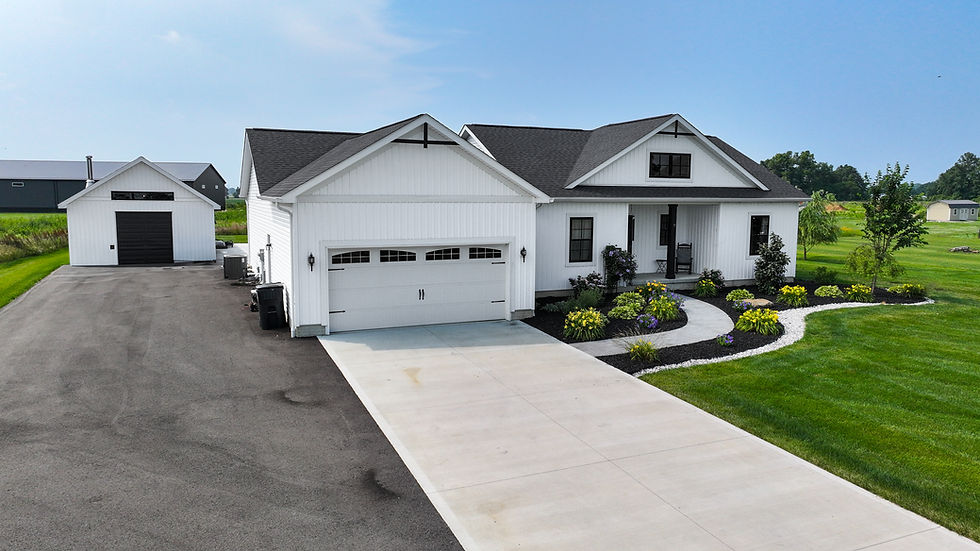
When it comes to showcasing commercial properties, first impressions matter more than ever. Traditional photography can only capture so much from the ground level. But what if you could elevate your visuals - literally? That’s where drones come in. These flying cameras are transforming how we capture commercial real estate, offering breathtaking perspectives and detailed insights that were once impossible or prohibitively expensive. Let me take you through why drones for real estate visuals are a game-changer and how they can elevate your property marketing to new heights!
Why Drones for Real Estate Visuals Are a Must-Have
Drones bring a fresh, dynamic angle to commercial real estate photography. Instead of static shots, you get sweeping aerial views that highlight the full scope of a property. Imagine showing off a sprawling industrial park, a multi-building office complex, or a retail center with a bird’s-eye view that captures layout, surroundings, and accessibility all at once.
Here’s why drones are indispensable:
Comprehensive Coverage: Drones can capture large properties in a single shot, showing the relationship between buildings, parking lots, and nearby infrastructure.
Unique Perspectives: Aerial shots reveal features like rooftop solar panels, landscaping, and proximity to highways or public transit.
Time Efficiency: Instead of setting up multiple ground shots, a drone can quickly scan and photograph the entire site.
Cost-Effective: Compared to helicopter or plane photography, drones are affordable and easier to deploy.
Marketing Impact: Stunning aerial visuals grab attention online and in brochures, making listings stand out.
If you want to impress potential buyers or tenants, drones provide a compelling visual story that traditional photography just can’t match.
How Drones Enhance Commercial Real Estate Photography
Let’s dive deeper into the practical benefits drones bring to commercial real estate photography. Beyond just pretty pictures, drones offer actionable insights and versatility.
Detailed Site Analysis
Drones equipped with high-resolution cameras can capture intricate details of a property’s condition. This is invaluable for:
Inspecting roofs for damage or wear without costly scaffolding.
Assessing parking lot layouts and traffic flow.
Monitoring landscaping and drainage issues.
Documenting construction progress or renovations.
Versatility in Shooting Angles
Unlike fixed cameras, drones can hover, circle, and zoom in on specific features. This flexibility means you can:
Capture panoramic shots that show the property in context with its neighborhood.
Highlight unique architectural elements from angles not possible on foot.
Create video flyovers that simulate a walkthrough experience.
Integration with Mapping and Data
Some drones come with GPS and mapping software, allowing you to create detailed site maps and 3D models. This is especially useful for land developers and environmental agencies who need precise spatial data.
Compliance and Safety
Professional drone operators follow strict regulations to ensure safety and privacy. This means you get high-quality images without risking accidents or legal issues.
If you want to explore more about how aerial shots can boost your listings, check out this resource on commercial real estate aerial photography.

How Much Money Do Aerial Photographers Make?
You might be wondering about the financial side of this booming field. Aerial photographers, especially those specializing in commercial real estate, can command impressive rates. Here’s a quick breakdown:
Entry-Level Drone Photographers: Typically earn between $30,000 and $50,000 annually, depending on location and experience.
Experienced Professionals: Can make $60,000 to $100,000 or more, especially if they offer specialized services like 3D mapping or video production.
Freelancers and Contractors: Often charge per project, ranging from $200 to $1,000+ depending on the complexity and size of the property.
The demand for drone photography in commercial real estate is growing rapidly, so skilled operators who combine technical expertise with creative vision are well-positioned to earn a solid income.
Practical Tips for Using Drones in Commercial Real Estate Photography
If you’re considering incorporating drones into your property marketing, here are some actionable recommendations to get the most out of your investment:
Hire Certified Operators: Ensure your drone pilot is licensed and insured. This guarantees compliance with FAA regulations and professional-quality results.
Plan Your Shots: Work with your photographer to identify key features and angles that best showcase the property’s strengths.
Schedule for Optimal Lighting: Early morning or late afternoon light creates dramatic shadows and highlights textures beautifully.
Use Video Alongside Photos: Aerial video tours can engage viewers more deeply than static images alone.
Incorporate Data Layers: If relevant, use drones with mapping capabilities to provide clients with detailed site plans or environmental data.
Respect Privacy and Permissions: Always get permission to fly over private property and avoid capturing neighboring homes or sensitive areas.
By following these tips, you’ll ensure your drone visuals are not only stunning but also professional and effective.
The Future of Commercial Real Estate Visuals with Drones
The technology behind drones is evolving fast. We’re seeing advances like:
AI-powered image analysis to detect property issues automatically.
Thermal imaging for energy audits and roof inspections.
Swarm drones that can cover large sites simultaneously.
Integration with virtual reality for immersive property tours.
At Sutable Aerial Solutions, we’re excited to be at the forefront of these innovations. Our drone imaging services don’t just save time and money - they provide precision and insights that help you make smarter decisions. Whether it’s crop management, invasive species control, or commercial real estate photography, drones are proving to be indispensable tools.
If you want to elevate your property marketing and gain a competitive edge, embracing drone technology is the way forward. Ready to take your visuals to new heights? The sky’s the limit!
Drones are no longer just gadgets for hobbyists - they’re powerful tools reshaping how we see and sell commercial real estate. With their ability to capture stunning aerial views, provide detailed site data, and enhance marketing efforts, drones are a must-have for anyone serious about property visuals. So why settle for ground-level shots when you can soar above the competition?


Comments