
AERIAL SURVEYING & MAPPING - NORTHERN OHIO - DRONE SERVICES

Enhance your outcomes with Sutable Aerial Solutions' professional aerial surveying and mapping specialized drone services. Our expertise lies in increasing crop yields through precise aerial data, showcasing real estate properties with stunning visuals, capturing live events from unique perspectives, and effectively managing biting insects and invasive plant species. Discover the significant impact that advanced aerial technology can have on your operations. We will assist you in achieving your objectives with accuracy and innovation.


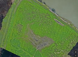
Sutable Aerial Solutions is your Northern Ohio partner for advanced drone surveying and mapping aerial solutions. Our FAA-certified and insured pilots leverage cutting-edge drone technology to deliver significant advantages for your projects.
Key Benefits of Our Aerial Surveying & Mapping Solutions
-
Enhanced Safety and Risk Reduction: Mitigate hazards by utilizing drones for inspections and surveys, keeping your personnel safely on the ground and out of harm's way.
-
High-Precision Drone Mapping: Achieve unparalleled accuracy in mapping and surveying for diverse sectors such as construction, agriculture, real estate, and environmental management. Our comprehensive aerial insights empower better planning and informed decisions.
-
Efficient Infrastructure Inspections: Conduct thorough drone inspections of critical infrastructure—including buildings, bridges, wind turbines, and solar panels—without the need for costly and risky scaffolding or manual methods.
-
Rapid Data Collection and Analysis: Transform tasks that traditionally took days into mere hours. Our drone services enable rapid data collection, providing you with analysis-ready information swiftly.
-
Eco-Friendly and Cost-Effective: Our drone services are designed to reduce your environmental footprint while simultaneously eliminating the expenses associated with traditional equipment and lengthy project timelines.
Ready to revolutionize your project with Sutable Aerial Solutions aerial surveying and mapping?


