
Sutable Aerial Solutions
High-Capacity Fleet Ready: Now Booking Mid-Summer Spraying, Mapping, and Waterfront Event Coverage.
Secure NDAA-Compliant Drone & Precision Ag Services

-
Zero Compaction
-
Precision Ag & Mapping
-
Thousand of Acres
Precision Agriculture & Custom Aerial Application in Ohio
NDAA Compliant & Blue UAS Government Drone
-
Government Ready
-
NDAA Complaint
-
Aerial Solutions
FAA Part 107 Licensed
PAMF Aligned
NDAA Compliant
Blue UAS & NDAA Compliant Hardware with Verfied Secure Data Chains
44807 Authorized
Fully Insured
The Sutable Advantage
Ohio's Choice


Beyond "flying drones": Sutable delivers industrial-grade application and verified data for Agriculture, Conservation, and Infrastructure.

Reliable. Precise. Insured. FAA Certified. Sutable.
The Sutable Team, Hometown Natives
Hometown Roots. High - Tech Execution.

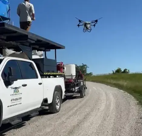
From the Lake Erie shoreline to the heart of the field - we provide the specialized Drone Solutions advantage Northern Ohio business deserve. Zero Footprint Advantage (no ruts, no crop damage, and the ability to spray when fields are to wet for ground rigs).
Licensed & Insured in specialized UAVs liability. Meet the Sutable Drone Team.
Projects
Invasive Plant Species Management - Wadsworth Marsh

Our team provided precision drone herbicide application services at Wadsworth Marsh in Port Clinton, Ohio. The goal was to eliminate existing vegetation and invasive grasses to prepare wetland acreage for waterfowl habitat development and seasonal duck hunting management.
Targeted aerial application efficiently treated 25 acres of saturated and difficult-to-access terrain without causing rutting or soil disturbance. Drone spraying provided accurate coverage, minimized impact to surrounding habitat, and allowed quick completion in areas where conventional machinery struggled.
Vegetation management projects like this are crucial for wetland and wildlife habitat planning. They help property owners establish high-quality food sources that attract migrating waterfowl while maintaining the long-term usability and productivity of their marshland environments.
Drone-ology Blog


Our support team is here to assist you with any inquiries, questions, availability.
We prioritize customer satisfaction and aim to provide timely and effective solutions.
Drone Solutions for Ohio: Every map is generated to meet the rigorous standards of the PAMF framework and municipal engineering requirements. WE DON'T JUST FLY - WE VERIFY!